The Home of My People
When Lewis and Clark stepped onto the Weippe Prairie in present-day Idaho in September 1805, they met the Nez Perce Indians. In the following years, the white explorers(探险者)began to fight with the Indians for their land. Some Nez Perce chiefs signed agreements with the U.S. government, selling part of their lands. But the government always broke those agreements and demanded more land.
Other chiefs refused to go along with the government’s plans. The most famous was Chief Joseph, whose people lived in the Wallowa Valley(present-day Oregon).
“In order to have all people understand how much land we owned,” he once explained, “my father planted poles around it and said: ‘Inside is the home of my people…It circled around the graves(坟墓)of our fathers, and we will never give up these graves to any man.’”
But in 1874, the U.S. government declared the valley open for white settlement and ordered the Nez Perce onto a reservation(保留地). Seeing that resistance was useless, Chief Joseph agreed to move.
Later fighting broke out between the Nez Perce and U.S. soldiers. Chief Joseph tried to lead his people to Canada, winning several battles against the soldiers during their flight. But finally, he was forced to give in.
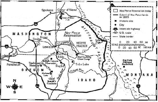
56. Which historic site (on the map)lies in the south of today’s Nez Perce Reservation?
A. Buffalo Eddy. B. Dug Bar.
C. Joseph Canyon Viewpoint. D. Chief Looking Glass Camp.
57. What can we learn about the Nez Perce lands from the map?
A. They were in the state of Oregon.
B. They have become a historic site.
C. They have become much smaller.
D. They were limited to the Wallowa Valley.
58. From Paragraph 3, we know that the Indians wanted to ______.
A. show off their land B. keep their land
C. turn their place into a graveyard D. build their homes around the poles
56---58 DCB
56.D点评:细节题。首先在地图中找到 Nez Perce Reservation参照,其次看选项:A. Buffalo Eddy位于 south west of NDR;B. Dug Bar同样位于 South west of NP.R;C. Joseph Canyon viewpoint位于 southwest to N.P.R;只有D. Chief Looking Glass Camp位于N.P.R的南部(south)。
57.C 点评:细节题,由地图标识可看出圈出的地盘New Perce Reservation today明显比粗线圈出的NewPerceReservationin1855小得多。所以选C。
58.B 点评:理解主旨,Nez Perce Reservation的领土受侵略日渐减少,Para.2讲到 Other chiefs refused to go along with the government’s plans.一些首领反对那些出卖领土的合约,并谈论到the most famous was Chief Joseph,第三段紧接着讲述的是这位著名首领采取的围护自己领土的措施,由此可见The Indians Wanted to keep their land。A. Show off their land炫耀他们的领土,不符主题。C、D都不符文章主旨。