问题 问答题

阅读短文,回答问题

磁  悬  浮  列  车

磁悬浮列车是由无接触的电磁悬浮、导向和驱动系统组成的新型交通工具,是高新技术的产物。上海磁悬浮列车示范运营线项目于2006年4月26日正式通过国家竣工验收。正线全长约30km,设计最高运行时速430km/h,单向运行时间7min20s。

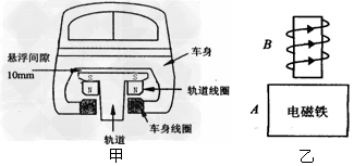
(1)上海磁悬浮列车的结构如图甲所示.要使列车悬浮起来,车身线圈的上端是_________极,它是利用_____________的相互作用,将车身托离轨道,大大减小了___________,使列车能高速运行。若列车总质量是20t,磁悬浮列车行驶时,强大的___________使列车上升10mm。 

(2)如果列车在单向运行过程中,只停靠一站,那么,停靠时间约为_________(设磁悬浮列车全程均以360km/h的速度行驶)。

(3)图乙是另一种磁悬浮列车的设计原理图,A是磁性稳定的电磁铁,安装在铁轨上,B是安装在车身上(紧靠铁轨上方)的电阻非常小的螺线管。B中电流方向如图乙所示,请在图中标出通电螺线管的N极,螺线管B与电磁铁A之间相互_________ (选填“排斥”或“吸引”),从而使列车悬浮在铁轨上方。

答案

(1)北  同名磁极互相排斥  摩擦  斥力(排斥力)  

(2)2min20s  

(3)B的下端是S极  排斥

选择题
单项选择题

Ten thousand years ago, as the last ice age drew to a close, sea levels around the world were far lower than they are today. Much of the land under the North Sea and the English Channel was part of a huge region of forests and grassy plains. Then the climate gradually became warmer and the water trapped in glaciers and ice caps was released. This ancient land was submerged in the resulting deluge and all that remains to tell us that it was once lush and verdant— and inhabited — is the occasional stone tool, harpoon or mammoth tusk brought up from the sea bed by fishing boats.
Now the development of advanced sonar technology, known as bathymetry, is making it possible to study this flooded landscape in extraordinary detail. While previous devices have only been able to produce two-dimensional images, bathymetry makes use of computers, satellite positioning devices and special software to create accurate and remarkably detailed maps. For the first time an ancient river bed leaps out of the three-dimensional image, complete with rocky ledges rising up from the bottom of the valley. The sites of pre-historic settlements can now be pinpointed, and it is also possible to see in stunning detail the sunken shipwrecks that litter this part of the sea bed.
According to archaeologist Dr Linda Andrews, this technological development is of huge significance. "We now have the ability to map the sea bed as accurately as we can map dry land," she says. She is, however, scathing about the scale of government funding for such projects. "We have better images of Mars and Venus than of two-thirds of our own planet! In view of the fact that Britain is a maritime nation, and the sea has had such a massive influence on us, it’s an absolute scandal that we know so little about the area just off our shores!"
Once bathymetric techniques have identified sites where people might have built their homes and villages, divers could be sent down to investigate further. The idea of Britain as a natural island kingdom will be challenged by these findings: Britain has been inhabited for about 500,000 years, and for much of this time it has been linked on and off to continental Europe. It remains to be seen how far this new awareness is taken on board among our "island" people.
In fact, the use of bathymetry scanners will not be limited to the study of lost landscapes and ancient settlements. It will also be vital in finding shipwrecks. Records show that there are about 44,000 shipwrecks off the shores of Britain, but there is good reason to believe that the real figure is much higher. In addition, commercial applications are a real possibility. Aggregates for the construction industry are becoming increasingly expensive, and bathymetry scanners could be used to identify suitable sites for quarrying this material. However, mapping the sea bed will also identify places where rare plants and shellfish have their homes. Government legislation may prevent digging at such sites, either to extract material for a profit or to make the water deeper: there are plans to dredge parts of the English Channel to provide deeper waterways for massive container ships.

How does Dr. Andrews feel about the lack of accurate information about the waters around Britain

A.(A) Outraged.

B.(B) Resigned.

C.(C) Astonished.

D.(D) Amused.