问题
综合
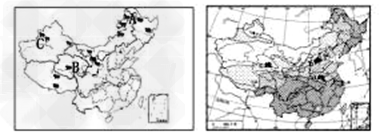
读“我国四大牧区分布图”与“我国干湿地区图”,完成下面各题。
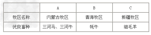
(1)填写表格。

(2)我国种植业与非种植业的界限大致与右图中的____线即________毫米等降水量线基本一致。
(3)种植业区内水田与旱田的界限大致与右图中的______线即_______毫米等降水量线基本一致。
(4)我国的四大牧区主要分布在____________(干湿地区),种植区主要分布在_____________(季风区或非季风区)。
答案
(1)
(2)b;400
(3)a;800
(4)干旱、半干旱地区;季风区